
How Wildfire Detection Software Helped to Avoid a Tragedy in Jaunciems
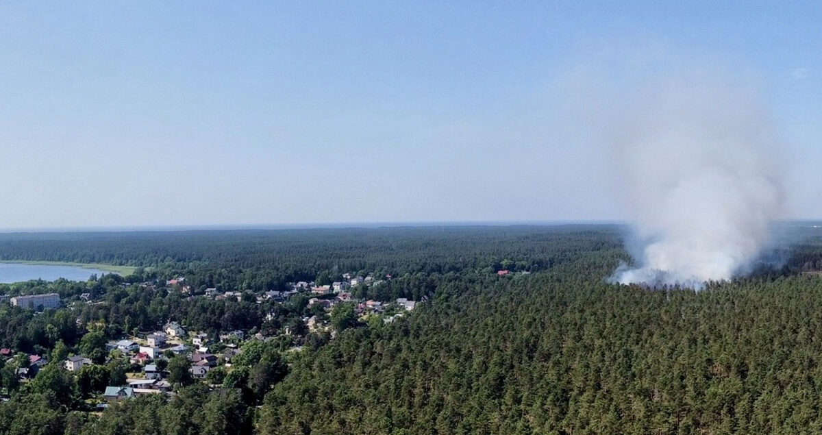
Photo: Emīls Gatis Liepiņš
It was just one step from a tragedy in Jaunciems – a territory located near Latvia’s capital city Riga. During one of the hottest summers ever recorded in the country, a wildfire started in the forest at Jaunciems just 300m away from houses. Most likely it started in several places simultaneously.
All strategic spots around Riga are equipped with cameras and software for wildfire detection. Two cameras are located in each spot. Cameras need to see the 360-degree territory so each of them is set to see 200-degrees just to be sure that the whole territory is covered. Cameras are rotating and software built with the help of artificial intelligence helps to detect smoke. In this case, the software also has a layer with GIS maps so not only the coordinates of the wildfire but also the owner of the territory in question can be easily ascertained.
No suspicions
In patrolling mode, a camera covers a range of 200 degrees in 10 minutes. There was no visible evidence that a fire had started, before another rotation cycle neither smoke nor flames could be seen by the camera monitoring the particular sector in Jaunciems. Suddenly an alarm signaling a suspicious object detected was raised. The person on duty started to investigate the situation by checking views from other cameras covering the region. In a couple of minutes, the approximate location of the wildfire was identified and at 2.59 PM State Fire and Rescue Service received a call.
It took about eight minutes from the moment of detection until the alarm was sent. Despite the fact that people could have been around, nobody saw the smoke or called the fire brigade. Therefore, it is almost certain that without cameras the wildfire would have been detected much later. Even if a person had called 112 to report a suspected wildfire, it would have been a much later stage when smoke and flames had already developed. It would have taken some minutes to explain the situation, even giving approximate positioning, and valuable time would have been lost before the fire brigade was notified. In all probability, this would not only have been a catastrophic delay, but one which meant that the fire brigade would have had to engage a lot more resources to tackle this wildfire.
In this case, experts believe that the most likely somebody ignited piles of branches that were left after the forest had been cleaned. However, in just 10 minutes the fire spread so quickly that 28 firefighters had to tackle the blaze and a total of 7 ha of forest was destroyed. If the fire had not been located so soon, it could have reached houses in minutes or spread across a copse where it could have become unstoppable.
The system is helping to prevent tragedies
Latvia’s wildfire detection system started operating from the start of the wildfire danger season in 2021. Two employees are on duty in the command center where all the relevant data is accessible through cameras. Nowadays it is easier to work for them as they do not have to focus on the screen all the time. The system does this. They only explore the situation when they receive a warning from the system as in this case.
It is possible to detect the location of the fire quite precisely if at least two cameras are used for fire monitoring. Latvia’s State Forest Service uses fire surveillance towers fitted with cameras to provide data. Together all this information is helping to prevent tragedies during Latvia’s hottest summer on record.